
Ever felt that rush when a trail makes your heart race? The Superior Hiking Trail goes on for over 300 miles along Lake Superior’s north shore. It invites you to step into a world where nature tells its own story.
Imagine strolling by old rock formations and through thick woods, with a cool breeze gently brushing past you. Every bend in the trail brings a fresh surprise and a chance to make a new memory.
This path challenges you just enough to feel truly alive while giving you moments to catch your breath from the daily grind. So grab your sense of adventure and hit the trail, each step is a little thrill waiting to happen.
Superior hiking trail Sparks Pure Excitement
Ever dreamed of a trail that feels like nature’s own story? The Superior Hiking Trail stretches over 300 miles along Lake Superior’s North Shore in Northern Minnesota. It starts at Jay Cooke State Park by the MN/WI border and winds up to a breathtaking lookout near Canada.
Built back in the mid-1980s and now part of the North Country National Scenic Trail, this path feels like a journey through time. Imagine walking among ancient volcanic ridges, more than a billion years old, made of rocks like basalt and rhyolite (simple volcanic rocks). The trail twists through lush forests, along high ridges, across winding river valleys, and past calm ponds, lakes, and streams.
Picture stopping at a sparkling waterfall, watching the water tumble into a deep gorge, a pause that turns a simple hike into a memory you’ll cherish. As you pass spots like Split Rock Waterfall, you might whisper, “This is nature’s art in motion.” And there are more delightful surprises along the way, from the sturdy wooden steps at Mount Trudee to the sweeping views of Bean and Bear Lakes, not to mention charming moments near Alfred’s Pond and Cross River. Each twist in the trail brings a fresh burst of rugged beauty and that undeniable spark of adventure.
Section-by-Section Breakdown of the Superior Hiking Trail

Imagine setting out on a trail split into seven unique parts, each with its own vibe and scenery. The very first part runs from the MN/WI border to Duluth over 50.2 miles, where the cool lake air and rugged rocks welcome you like the opening lines of a great story. In Section 2, you journey 57.2 miles from Duluth to Two Harbors, with breathtaking water views and the relaxed charm of small lakeside towns to keep you company.
Section 3 covers 44.6 miles from Two Harbors to Silver Bay, featuring gentle hill climbs and quiet woods that feel like a soft whisper in the forest. Then comes Section 4, stretching 45.3 miles from Silver Bay to Caribou Falls, where the rush of waterfalls and clear streams really wake up your senses. Section 5 heads from Caribou Falls to Lutsen over 34.5 miles, mixing rocky paths with shaded wood lanes for a varied stroll. Next, Section 6 links Lutsen to Grand Marais in 35.2 miles, treating you to wide, open views across the land. Finally, Section 7 runs 54.2 miles from Grand Marais to a 270° Overlook, where you can stand in awe as nature opens up in every direction.
| Section | Start – End | Distance (mi) |
|---|---|---|
| 1 | MN/WI Border – Duluth | 50.2 |
| 2 | Duluth – Two Harbors | 57.2 |
| 3 | Two Harbors – Silver Bay | 44.6 |
| 4 | Silver Bay – Caribou Falls | 45.3 |
| 5 | Caribou Falls – Lutsen | 34.5 |
| 6 | Lutsen – Grand Marais | 35.2 |
| 7 | Grand Marais – 270° Overlook | 54.2 |
Mapping Tools and Navigation for the Superior Hiking Trail
Official paper maps for the Superior Hiking Trail are useful, but they’re often small and can sometimes miss the mark. These days, lots of hikers turn to digital tools like CalTopo and Gaia GPS for real-time updates. They let you explore trails on interactive maps and check out detailed route views. Imagine glancing at a mile marker and then confirming your spot on your GPS, it's like watching your trail come to life.
Mileage markers along the main path give you a good heads-up, but you really need extra tools when you’re in remote spots like Otter Tail Road where cell service is thin. Downloading maps and using GPS coordinates helps you stay on track and avoid unexpected turns. One fellow hiker once said it feels like having a trusty friend next to you, pointing out every twist and turn. That kind of support makes tackling tough terrain feel a little less intimidating.
Using both a paper map for the big picture and a modern GPS for pinpoint details gives you the best of both worlds. This combo lets you plan your adventure with confidence while enjoying every part of the trail safely.
Camping and Lodging on the Superior Hiking Trail
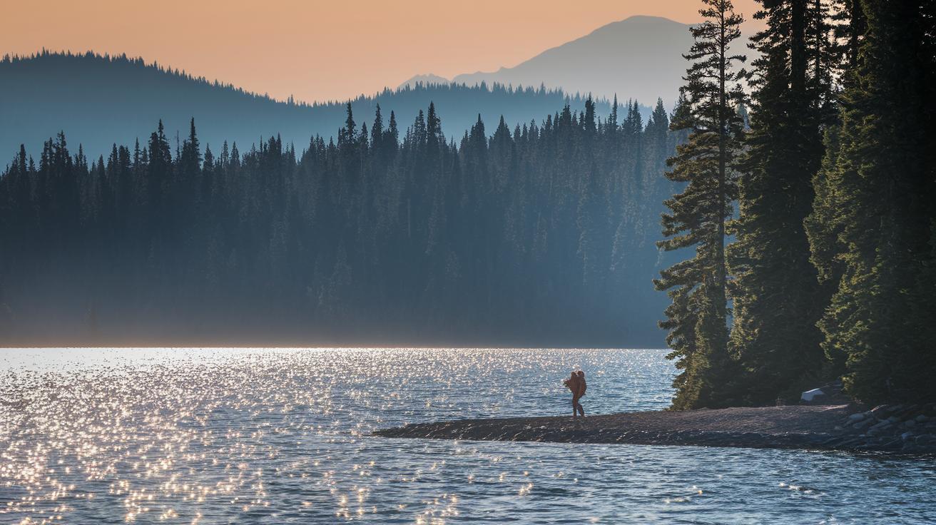
Hitting the Superior Hiking Trail is like uncovering hidden camping gems along your journey. At Agnes Lake’s peninsula, you can catch the sunrise sparkling on the water, it’s like nature’s friendly nudge to get your day started. Picture waking up with gentle waves whispering nearby and a soft breeze teasing your face. With underground streams and easy water access, these backcountry spots offer a refreshing escape during your trek.
Designated Backcountry Campsites
One cool spot is the Poplar River overlook, it sits high above with wide, sweeping views and water close by. Over at Lookout Mountain in Cascade River State Park, rocky outcrops and shady corners invite you to kick back and enjoy nature’s calm. And then there’s Pincushion Overlook off the Gunflint Trail, where breathtaking views make you feel like you’re on top of the world. Each campsite is picked for its unique terrain and water sources, like little treasures waiting to be discovered along your favorite path.
Nearby Town Lodging
Sometimes you might want a break from sleeping under the stars. Towns like Duluth, Two Harbors, and Silver Bay offer budget-friendly inns and hostels where you can warm up, share stories with fellow hikers, or savor a hearty meal before setting off again. And before you trade the campsite for a cozy room, check out the camping essentials checklist at https://blackandburlap.com?p= so you’re always ready for the wild adventure ahead.
Seasonal and Difficulty Guide for the Superior Hiking Trail
Fall is a time when nature shows off its best colors. Imagine maples and aspens lighting up the trail with brilliant reds and golds. It feels like walking through a living painting, and it’s perfect for anyone who loves a scenic, relaxed hike.
Summer, especially in June, tells a different story. Think about trekking under a blazing sun with sticky air and bugs that just won’t give you a break. One hiker once said, "I remember trudging through a humid June day, sweat dripping as I conquered a tricky section." That really sums up the challenge and raw energy of a summer hike.
The trail has routes for every kind of adventurer. Some segments are like a peaceful lakeside walk, easy on your legs and soothing to your spirit. Meanwhile, spots near Gooseberry and Split Rock state parks throw in some steep rock climbs (a fast, steep climb) that really test your skills. And then there’s Mount Trudee with its wooden steps and sudden bursts of steep terrain that make you pause and catch your breath.
- Fall: Perfect for vibrant scenery and gentle paths
- Summer: Demanding with intense heat, pesky insects, and challenging climbs
Each part of the hike has its own ups and downs. Whether you’re planning a leisurely stroll or gearing up for a vigorous adventure, knowing the season and trail difficulty helps you prep just right.
Logistics: Transportation, Permits, and Shuttle for the Superior Hiking Trail
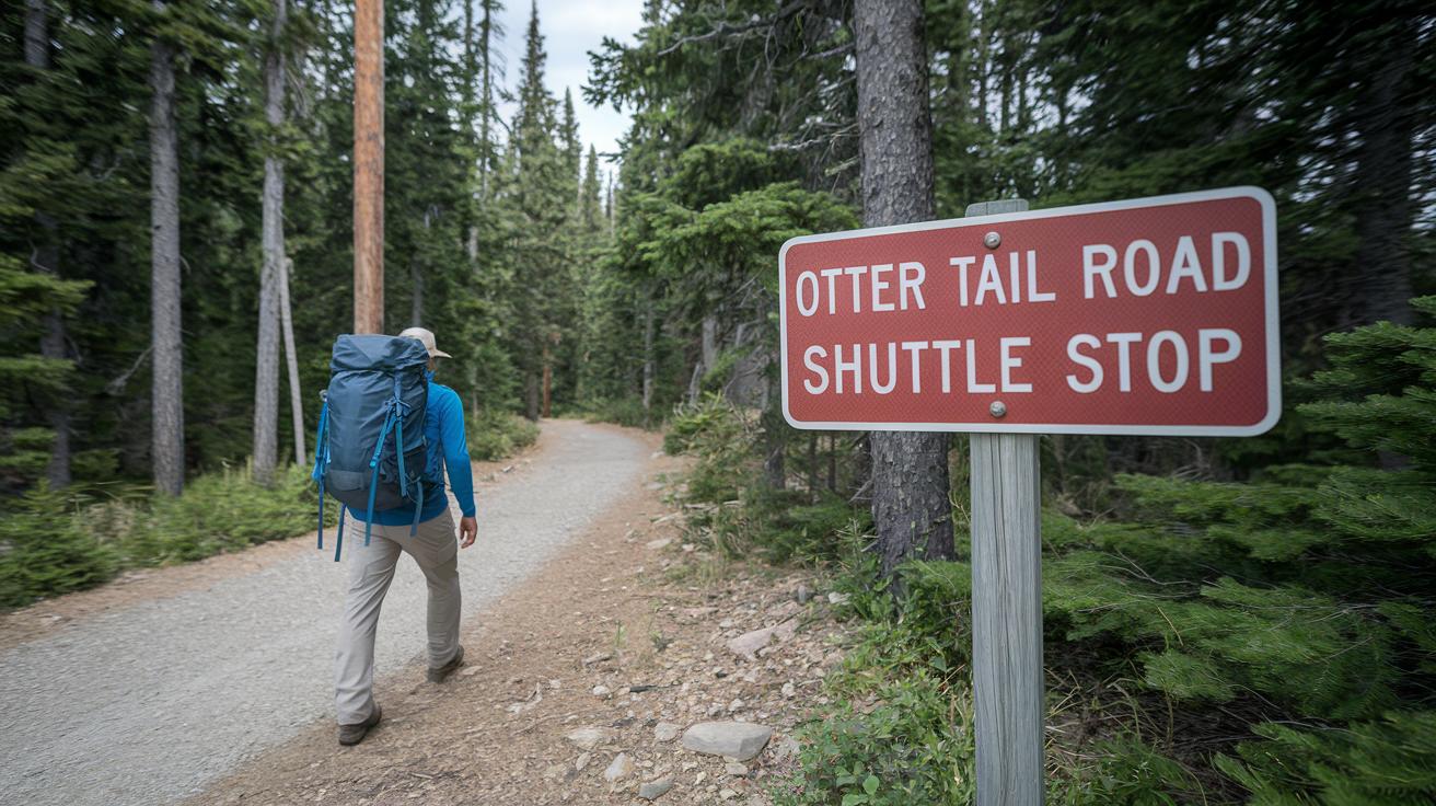
Planning your adventure on the Superior Hiking Trail means thinking ahead a bit, especially if you’re headed to remote spots. Some trailheads, like the one off Otter Tail Road, don’t offer much by way of public transit. But don’t worry too much, if you need a lift, the Superior Hiking Trail Association runs a shuttle that usually costs between $30 and $50 each way. Remember, when you’re setting out from popular areas like Jay Cooke State Park or Grand Marais, you often need a day-use permit for parking, so take a close look at the local signs before you head out. And keep in mind, drop-off and pick-up times can change with the seasons, so it’s smart to check the seasonal schedules.
- The shuttle schedule for remote trailheads is arranged locally.
- Local shuttle services help get you to far-off sections of the trail.
- Parking at many trailheads usually needs day-use permits, not backcountry ones.
- The association clearly posts the ride fee details for the shuttle.
Make sure you double-check current permit rules and shuttle times before venturing into remote areas. A little extra planning now means more time to soak in the crisp air, stunning views, and the challenge of the trail without any transport hiccups.
Essential Gear and Safety Precautions for the Superior Hiking Trail
Planning a hike? Pack light and pack smart. Use trail runners that aren’t waterproof so you don't get weighed down by extra moisture. And don’t forget an extra pair of socks to change into after creek crossings or soggy steps. With a sudden downpour always a possibility, a rain shell or poncho in bright colors is a must.
A simple map and compass, or a trusty GPS, help keep you on track, while a 2–3 L hydration reservoir makes sure you stay refreshed mile after mile.
Wildlife sightings are rare, so it pays to store your food properly. Staying alert with a way to send an emergency signal or checking in with a hiking buddy adds extra confidence when you're far from home.
Wildlife and Remote-Excursion Safety
- Trail runners or lightweight boots
- An extra pair of moisture-wicking socks
- A waterproof rain shell or poncho
- A topographic map or reliable GPS device
- A 2–3 L hydration reservoir
- A basic first aid kit
Keep a whistle or signal mirror handy when exploring remote stretches. Let a friend know your plans and check in often. One hiker once said, "I always carry a small charger in case my GPS runs low." A little extra care makes every step feel more secure and turns unexpected challenges into small bump-in-the-road moments. For more gear tips, check out essential backpacking gear.
Final Words
In the action, we explored trail highlights, mapping tools, camping tips, gear musts, and seasonal advice that guide every step. We broke down sections so you can see clear mile markers and reviewed ways to keep safe with smart equipment choices. These insights help set you up for a memorable outdoor trip. Get ready to pack up, hit those winding paths, and enjoy every view on the superior hiking trail. Enjoy each moment and embrace the clear, open air ahead.
FAQ
Superior Hiking Trail Store
The Superior Hiking Trail Store refers to online and local outlets where you can pick up gear, maps, and supplies geared to help hikers get set for the SHT.
Superior Hiking Trail Map
The Superior Hiking Trail Map shows trail routes, mile markers, and key landmarks. Many hikers use digital tools like CalTopo or Gaia GPS to get real-time positions and detailed topographic info.
Superior Hiking Trail Length
The Superior Hiking Trail Length is over 300 miles along Lake Superior’s North Shore in Northern Minnesota, offering a mix of forest, shoreline, and rugged terrain to explore.
Superior Hiking Trail Thru-Hike
The Superior Hiking Trail Thru-Hike means hiking the entire route from start to finish, typically taking about 2–3 weeks, depending on your pace and how much time you rest along the way.
Superior Hiking Trail: Duluth
The Superior Hiking Trail: Duluth segment is an important part of the SHT, providing access to city amenities and serving as a gateway for exploring the scenic route along Lake Superior.
Superior Hiking Trail Directions
The Superior Hiking Trail Directions come from posted mile markers and clear trail signage. Digital maps and GPS services also help guide hikers through the remote paths and tricky sections.
Superior Hiking Trail Reddit
The Superior Hiking Trail Reddit threads are a great space where fellow hikers share personal experiences, advice, and recent conditions of the trail, making it a useful resource for recent updates.
Superior Hiking Trail Shuttle
The Superior Hiking Trail Shuttle offers transport between remote trailheads. Operated by the trail association, it usually costs between $30–$50 per ride, making logistics a bit easier for hikers.
How long does it take to hike the Superior Hiking Trail?
The Superior Hiking Trail typically takes about 2–3 weeks to complete, with timing depending on your pace, rest days, and varying terrain conditions along the trail.
What is the best section of the Superior Hiking Trail?
The best section of the Superior Hiking Trail is subjective. Many appreciate the Duluth to Two Harbors leg for its striking Lake Superior views, diverse terrain, and engaging forest and shoreline paths.
Do you need a permit for a Superior Hiking Trail?
You do not need a permit for hiking the backcountry of the Superior Hiking Trail, although some trailhead parking areas require day-use permits for access.
What is the hardest hiking trail in the US?
The hardest hiking trail in the US is often debated. While the SHT can be challenging in parts, many hikers consider trails with steeper, more rugged climbs in other regions to be tougher overall.