
Ever thought that a steep climb and the glow of a new day could set you up for something amazing? Mission trail hikes mix tough climbs with peaceful spots where you can take in the crisp air. I've found a few paths that not only get your heart pumping but also treat you to clear, bright views that wake you up, like the calm on Cowles Mountain. Picture stepping into that cool rush or joining a gentle loop that just feels right. Let’s head out together and check out these trails that offer both a solid workout and a moment to just be.
Mission Trails Hikes: Inviting Scenic Paths
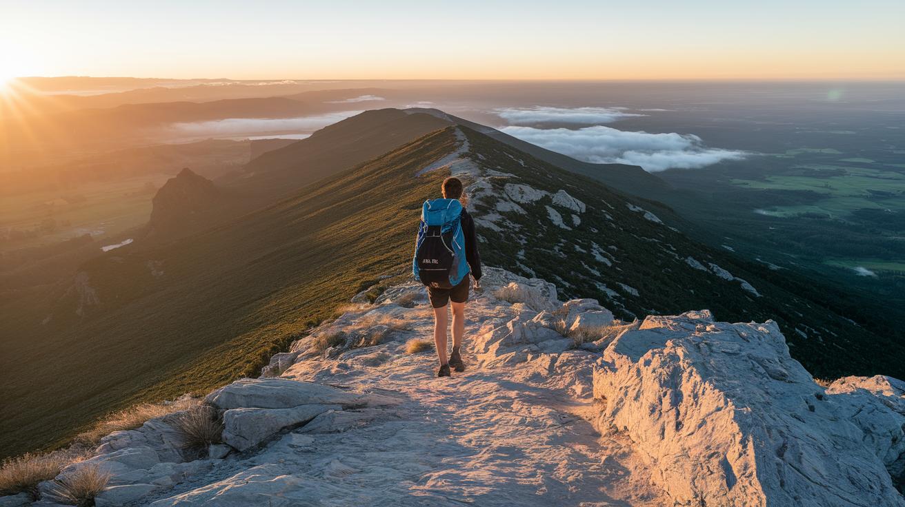
Cowles Mountain Trail offers a short but tough 3-mile adventure that lifts you nearly 1,000 feet. You start along Golfcrest Drive, where the parking lot is small and fills up quick, so street parking might be your best bet. Try to set off early before the sun peeks over the mountain; it means quieter trails and clear, bright skies. Starting early gives you that calm, peaceful beginning and sets a nice steady pace for your day.
Once you reach the top of Cowles, the path stretches into the Pyles Peak Extension. This extra 1.5 miles is a bit less intense though it still involves steep climbs and just as steep descents. It’s a neat add-on if you’re chasing a five-peak challenge without switching trails. Imagine pushing through that extra bit and thinking, “That climb was totally worth it!”
Next up, check out Kwaay Paay Peak. This compact 2.4-mile round trip packs a punch, lifting you about 1,194 feet. Starting at Father Junipero Serra Trail, the route is tough, with quick, strong bursts of climbing that demand your focus. Picture hitting that steep incline and feeling the rush of cool, high mountain air as you rise higher.
The North & South Fortuna Loop is another great option. This 6-mile circuit mixes steep sections with more moderate parts. The continuous loop means you tackle the hardest stretches only once, saving energy while still getting a solid workout. It’s a smart way to blend challenge with efficiency if you’re tallying up your mileage.
If you’d prefer something gentler, try the South Fortuna via Fortuna Saddle loop. At about 5 miles, its well-kept paths and steady climb offer a pleasant mix of effort and exhilaration, perfect for a day of balanced adventure.
| Trail | Round-Trip Mileage | Elevation Gain | Difficulty | Starting Point |
|---|---|---|---|---|
| Cowles Mountain Trail | 3 mi | 1,000 ft | Strenuous | Golfcrest Dr. |
| Pyles Peak Extension | +1.5 mi | Steep ascent/descent | Moderate | From Cowles summit |
| Kwaay Paay Peak | 2.4 mi | 1,194 ft | Strenuous | Father Junipero Serra Trl |
| North & South Fortuna Loop | ~6 mi | Variable | Moderate to Strenuous | Main loop area |
| South Fortuna via Fortuna Saddle | 5 mi | Steady climb | Intermediate | Fortuna area |
A handy tip for planning your day: head out before 7 AM to beat the crowds, take a break by Kumeyaay Lake for a refreshing water sip, and plan your summit stops when the morning air is still cool. Just remember, pause, take a sip, and let those panoramic views fill you with wonder as you conquer each peak.
Visitor Center Map Tour & Parking Facility Details

At Mission Trails Visitor Center, you’re welcome every day from 9 AM to 5 PM. You can pick up a free trail map or a printable PDF guide to help plan your adventure. The maps clearly point out favorite spots like Kumeyaay Lake, Old Mission Dam, Fortuna Campground, and the Four Corners intersection, making it easier to find your way.
Parking changes a bit around the park. The Visitor Center has a lot with 50 spaces, but the small lot at Cowles Mountain fills up fast. The Father Junipero Serra lot is even tighter with only 12 spaces. If all these lots are full, you can always try street parking along Murray Canyon or Golfcrest – just remember the 2-hour limit.
Imagine arriving early at the map counter. Grab that PDF map at sunrise and feel the thrill, like you’re holding a secret key to unknown trails. This smart plan for both parking and getting your map sets up a smooth day on these beautiful, inviting paths.
Family Outdoor Walks & Hidden Footpaths Off the Beaten Track

For families and young adventurers, these secret paths offer a gentle pace and beautiful views to savor. Try out the Tranquil Five-Mile Loop. It trails along a quiet service road on Cowles’ backside and slowly rises toward the summit. Imagine strolling where the mountain air is fresh and nature whispers its tales. It’s a laid-back way to enjoy the outdoors with your loved ones, with no rush, just simple, honest fun.
Then there’s the Visitor Center Ridge Route. This short, 2-mile round trip starts on a smooth, paved way, then surprises you with a steeper climb leading to jaw-dropping cliffside views that rock climbers love. Picture passing a friendly sign that says, “Step up here for a view you won’t forget!” while your kids gaze out at endless horizons.
Another great pick is the West Fortuna Loop. At 3 to 5 miles long, it winds through Corte Playa Catalina, Suycott Valley, and hints of trails like the Rim Trail or Shepherd Pond Loop. This path takes you through areas where new plants are starting to grow, giving you a fresh twist on familiar scenes.
- Kid-friendly tips:
- Enjoy water games at Kumeyaay Lake.
- Take short breaks to spot wildlife.
- Use the handy restroom at Four Corners.
Mountain Safety Tips & Wilderness Campsite Advice

Kick off your day early, around 8 AM is a great time to hit the trail. This lets you slowly warm up and enjoy the cooler morning air before the heat sets in. Bring along at least 2 liters of water per person, and don’t forget your hat and sunscreen for extra protection. Keep your eyes peeled for rattlesnakes on those less-traveled paths. Picture yourself checking your water bottle and scanning the surroundings, feeling relaxed and ready for whatever the trail brings.
On weekends, you might want to join a ranger-led eco tour that starts at 10 AM. These tours, free with park entry, are like gathering around a campfire and listening to a local guide share genuine trail insights. It’s a fun way to learn about the area and pick up some handy tips. And if you’re planning to join one, a quick reservation is a smart move, especially when the trails get busy.
Planning to spend the night out in the wild? Consider booking a spot at Fortuna Campground for roughly $15 per night. Remember that wilderness camping in the park means you’ll need a permit and reliable, bear-proof food storage to keep critters at bay. Just imagine setting up your shelter in a safe, designated area, knowing that you’ve taken care of details like weather swings, whether summer temperatures soar above 90°F or drop below 45°F in winter.
-
Mountain safety tips:
- Begin your hike early
- Bring enough water
- Keep a lookout for rattlesnakes
-
Wilderness campsite advice:
- Check permit requirements
- Use bear-proof food storage
Scenic Ridge Vistas & Cultural Background Highlights

If you're ready for a memorable photo adventure, hit these park overlooks for some truly amazing moments. At sunrise, stand at Cowles Summit and let the early light bathe the rugged peaks in a warm, golden glow. Then, wander over to the Old Mission Dam spillway to watch water flow with a natural rhythm that turns an ordinary sight into something really striking. And don’t forget to pull over at Sheep Creek Overlook on the Rim Trail, where the light can suddenly feel magical, perfect for that picture that tells its own story.
These trails follow the same paths that the Kumeyaay people once traveled many years ago. The Old Mission Dam, built over 200 years back, is California's oldest dam, and its weathered stones whisper tales of history. At the Visitor Center, you'll find panels full of stories about the Kumeyaay heritage, early ranching days, and even hints of Mission San Diego ruins. This mix of history and breathtaking views invites you to stop, reflect, and capture both nature and its rich past in one shot. Ever felt like a single sunrise could share the story of every footstep on these ancient trails?
Final Words
In the action, this post brought you top tips on tackling five peak summits, a quick guide to maps and parking, and family walks along hidden footpaths. We talked through safety measures and campsite notes, and rounded it off with ideas for scenic ridge views and cultural insights. Armed with these practical tips and a fresh outlook, you’re set to enjoy mission trails hikes and make the most of every trail under the open sky. Enjoy the time outdoors and take along these ideas for your next day out.
FAQ
Q: What does “mission trails hikes map” refer to?
A: The mission trails hikes map guides you through the park with route details like distances, trail names, and start points. It helps you plan your outdoor walk with ease.
Q: What is Mission Trails Regional Park?
A: The Mission Trails Regional Park is a large natural area featuring various trails, scenic overlooks, and cultural sites. It welcomes both quick family walks and longer, challenging hikes.
Q: What are considered the best mission trails hikes?
A: The best mission trails hikes offer routes that suit both laid-back walkers and those seeking a tough climb. They combine striking views and diverse terrain to cater to different activity levels.
Q: What does the mission trails map pdf provide?
A: The mission trails map pdf gives a digital guide showing trail layouts, important landmarks, and parking spots. It’s a convenient printout to help you choose the right route.
Q: What is the Mission Trails 5 Peak Challenge?
A: The Mission Trails 5 Peak Challenge involves hiking to five summits in one outing. It pushes your endurance and rewards you with panoramic views from several high points in the park.
Q: How long is a Mission Trails hike?
A: The length of a Mission Trails hike depends on the route chosen. Options range from short loops of about 2 miles to longer treks over 6 miles, suiting different time frames and energy levels.
Q: What characterizes the Father Junipero Serra Trail?
A: The Father Junipero Serra Trail is a steep, respected route known for its striking views and historical significance. It offers hikers a chance to mix physical effort with local cultural insights.
Q: What are the Mission Gorge Trails like?
A: The Mission Gorge Trails feature a rugged path through canyon areas and rocky surfaces. They work best for seasoned hikers who look for a mix of physical challenge and breathtaking natural scenes.